
Clonfertmulloe
AKA Old Kyle Cemetery
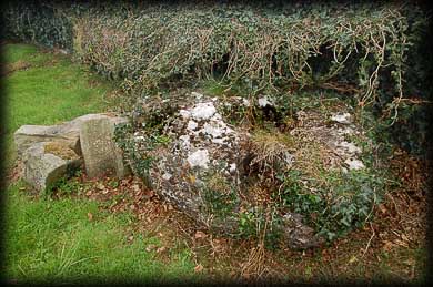
It was such a pleasure to wander around this old graveyard. I entered the cemetery via the old stone stile to the left of the gate. The antiquities here are not that obvious, they don't jump up and hit you in the face, but immediately to the right of the gate is an enormous bullaun stone. It is hard to imagine because of the size, but this stone is almost hidden beneath ivy. It is an irregular shaped conglomerate with five bullauns in the top. Considering its history the condition of this stone is dreadful.
This is the stone of St M'Loo, see St Molua, originally sited in a field next to the graveyard. Tradition states that the saint knelt so often upon the stone to weep and pray that he wore five holes in its surface - two by his knees, one by his clasped hands, and two by his tears. The holes worn by his tears are on the right side of the stone. St M'loo founded a church here in the 6th century. Further along the wall, standing right up against it is a cross inscribed slab. This is one of two said to be located here but I could only find this one. Towards the centre of the graveyard are the scant remains of a medieval church pictured right.


Situated: From Borris in Ossary head west on the N7. After 1.7 kilometres turn right. Then take the first left. After a further 2 kilometres turn right. The cemetery is 500 metres down this road on your left. In the field before the cemetery is a standing stone.
Discovery Map 54: S 233 901. Last visit April 2010.
Longitude: 7° 39' 11.60" W
Latitude: 52 ° 57' 40.38" N
Photos: Jim Dempsey.
