Fore Wayside Crosses

Fore Wayside Crosses
Eighteen crosses were situated along the pilgrim trail within a 10 kilometre radius of Fore. Collectively known as the Fore wayside crosses, some of the 17th century crosses are quite plain and some are decorated. I am listing the crosses in reverse order, starting at No 17. Known as the school cross this 1.4 metre high cross stands in a recess in the wall at the front of St Feichin's National School. It has a solid ring and bears no decoration. A socket from cross No 18 is said to have been placed at the base of the school cross, but it is no longer visible. From here walk west towards the village.
Longitude: 7° 13' 20" W, Latitude: 53° 40' 40" N

Cross head


Wayside Cross Windtown, Fore
Crawford No 16
This rather cute 0.69 metre high cross now stands in the centre of Fore Village. It was moved to here from the graveyard at St Mary's Church. It has a solid ring with a crucifixion carved on the south face. The cross is set in a large pyramidal shaped base. During the 18th and 19th centuries funeral processions would follow the line of these crosses halting at each one in turn for special prayers.
Longitude: 7° 13' 35" W, Latitude: 53° 40' 48" N
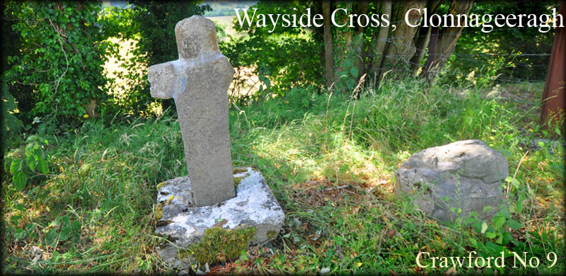
Wayside Cross, Fore
Crawford No 15
According to H.S.Crawford No 15 is a small plain cross with a solid ring, kept in St Feichin's Church. The only small cross we could find in the church is decorated with a marigold design. See Crawford No 9.
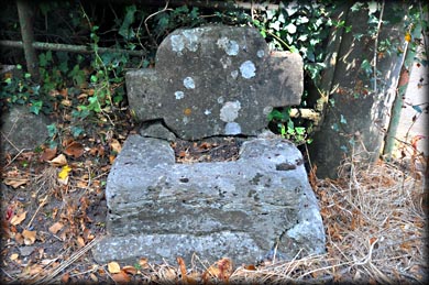
Wayside Cross, Lakill and Moortown
Crawford No 14
This cross is hidden in the the hedgerow, on the east side of the road, north of the town gate. It is described as a base with a piece of shaft cemented into it and two decorated fragments of the head.
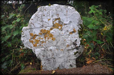
Wayside Cross, Lakill and Moortown
Crawford No 13
This cross is situated on the north side of the road, about 1 kilometre west of Fore village. Only the head and base of the cross survive. The top arm of the cross is also missing. The cross head is probably the plainest I have ever seen, with no features whatsoever. The base, like most of those at Fore appears to be too big for the cross. it may have been a stepped base originally, but the upper portion, has been poorly repaired with cement.
Longitude: 7° 15' 3" W, Latitude: 53° 41' 11" N
Wayside Cross, Ben
Crawford No 12
This cross was known as St Fechin's Cross, but all that remains is a small mound on the south side of the road to Oldcastle, north east of Fore. Once described as a rectangular platform on top of a natural rise. It is situated on the east side of a field gate. The numbers allocated to the crosses does not appear to follow any logical sequence from here. Check the link Westmeath map.
Longitude: 7° 12' 49" W, Latitude: 53° 41' 50" N.

Wayside Cross, Ben
Crawford No 11
Longitude: 7° 13' 30" W, Latitude: 53° 41' 15" N

Wayside Cross, Ben
Crawford No 10

Wayside Cross, Fore
Crawford No 7
Longitude: 7° 14' 46" W, Latitude: 53° 42' 24" N
Wayside Cross, Foyran
Crawford No 3
The head of this cross now sits on the top of a field bank on the west side of the road, opposite Foyran Church. The left arm is completely broken off, and part of the right arm is missing. The east face bears a crudely incised crucifixion. You can clearly see the arms and the image shown right. I believe the is a single marigold carved in the centre of the west face, but this was impossible to see because of the vegetation on that side.
Longitude: 7° 17' 49" W, Latitude: 53° 44' 49" N


Wayside Cross, Foyran
Crawford No 2
Longitude: W, Latitude: N
Wayside Cross, Foyran
Crawford No 1
Longitude: W, Latitude: N
Situated:
Discovery Map 41: N 5112 7031. Last visit July 2018.
Longitude: 7° 13' 35" W. Fore village cross No 16.
Latitude: 53° 40' 48"N.
Photos: Jim Dempsey